Randonnée A pied La Châtre - Entre Berry et Bourbonnais - Photo

Entre Berry et Bourbonnais

 zefreefly
zefreefly

Utilisateur

© OpenStreetMap contributors
Longueur
Longueur
191 km
Altitude max
Altitude max
502 m
Dénivelé positif
Dénivelé positif
2718 m
Km-Effort
Km-Effort  
227 km
Altitude min
Altitude min
180 m
Dénivelé négatif
Dénivelé négatif
2718 m
Boucle
Boucle
Oui
Date de création :
2022-09-01 12:52:06.469
Dernière modification :
2022-09-01 12:54:53.029

(0 Avis)

A pied
A pied
51h33
Difficulté : Très difficile

Scannez ce code QR pour ouvrir la randonnée dans l'application SityTrail

Application GPS de randonnée GRATUITE

Logo SityTrail SityTrail

IGN / Instituts géographiques

Télécharger SityTrail sur l'App Store Télécharger SityTrail sur Google Play

Logo SityTrail SityTrail World

Le monde est à vous

Télécharger SityTrail sur l'App Store Télécharger SityTrail sur Google Play Télécharger SityTrail sur Huawei AppGallery

À propos

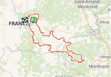
Randonnée A pied de 191 km à découvrir à Centre-Val de Loire, Indre, La Châtre. Cette randonnée est proposée par zefreefly.

Description

Sur les pas des Maîtres Sonneurs entre Berry et Bourbonnais

Profil altimétrique

Localisation

Pays :
France
Région :
Centre-Val de Loire
Département/Province :
Indre
Commune :
La Châtre
Localité :
Unknown
Départ:(Dec)
Départ:(UTM)
422352 ; 5159178 (31T) N.

Randonnées à proximité

Randonnée Marche La Châtre - Sur les pas des Maîtres Sonneurs (La Châtre - La Berthenoux) - Photo
Marche
tracegps

Marche

Difficile
La Châtre, Centre-Val de Loire, Indre, France
18,5 km | 21 km-effort
4h 40min
Non
Randonnée A pied Lourouer-Saint-Laurent - Circuit pédestre n°34
A pied
fanthou

A pied

Facile
Lourouer-Saint-Laurent, Centre-Val de Loire, Indre, France
6,4 km | 7,1 km-effort
1h 36min
Oui
Randonnée A pied Montgivray - Circuit pédestre n°13
A pied
fanthou

A pied

Facile
Montgivray, Centre-Val de Loire, Indre, France
7,5 km | 8,5 km-effort
1h 55min
Oui
Randonnée Marche Le Magny - Circuit pédestre n°10
Marche
fanthou

Marche

Facile
Le Magny, Centre-Val de Loire, Indre, France
6,2 km | 7,7 km-effort
1h 44min
Oui
Randonnée Marche Chassignolles - Circuit pédestre n° 2
Marche
fanthou

Marche

Très facile
Chassignolles, Centre-Val de Loire, Indre, France
3,3 km | 3,8 km-effort
52min
Oui
Randonnée Marche Nohant-Vic - boucle noyant vic - Photo
Marche
fab0202

Marche

Facile
Nohant-Vic, Centre-Val de Loire, Indre, France
10,6 km | 12,1 km-effort
2h 20min
Oui
Randonnée Marche Nohant-Vic - Nohant - Photo
Marche
jlrayon

Marche

Facile
Nohant-Vic, Centre-Val de Loire, Indre, France
5,2 km | 5,9 km-effort
1h 20min
Oui
Randonnée Marche Nohant-Vic - petite boucle nohant - Photo
Marche
fab0202

Marche

Facile
Nohant-Vic, Centre-Val de Loire, Indre, France
3,7 km | 4 km-effort
55min
Oui
Randonnée Marche La Châtre - La Châtre    Cluis - Photo
Marche
Lionel_72

Marche

Moyen
La Châtre, Centre-Val de Loire, Indre, France
30 km | 34 km-effort
6h 57min
Non


Fermer
Mes abonnements